 |
Back
to Märjelen |
 |
Text and photos Michel AZEMA
| Brig am Simplon Canton of Valais, Switzerland 1999, September 7th Brig Valais, Suisse 7 Septembre 1999 |
My
love and my fascination to the Swiss Alps and their glaciers attracted
me for the third time to the glacier of Aletsch in the upper Valais. If
you still don't know, the glacier of Aletsch is the biggest of continental
Europe with 24 kilometers long. It is composed of the ices of some different
glaciers whose main are Grosser Aletschfirn, Jungfraufirn and Enigschneefeld
which join at Konkordiaplatz. Mon amour et ma fascination pour les Alpes suisses et de ses glaciers m'ont attiré pour la troisième fois vers le glacier d'Aletsch dans le Haut-Valais. Pour ceux qui l'ignore, le glacier d'Aletsch est le plus grand glacier d'Europe continentale avec 24 kilomètres de long. Il est formé des glaces de différents glaciers dont les trois principaux sont Grosser Aletschfirn, Jungfraufirn et Enigschneefeld qui se rejoignent à Konkordiaplatz. |
|
Ride to Märjelen
Balade vers Märjelen |
|
|
Click to enlarge
Cliquez pour agrandir |
Along
the glacier of Aletsch there is a special place which is more fascinating,
this is an intermittent lake called Märjelensee. The waters of Märjelenalp
tries to flow down but are stopped by the mass of the glacier and a lake
is formed close to the ice. This lake has green water and icebergs are
floating. Because the glacier is continually moving, sometime there is
a crack in the glacier below the surface of the lake and then the water
of the lake is siphoned and completely disappears under the ice. Only
the icebergs remain on the bottom of the empty lake. Le long du glacier d'Aletsch il y a un endroit encore plus fascinant, il s'agit du lac de Märjelen qui est en fait un lac intermittent. Les eaux de l'alpe de Märjelen coulent vers la vallée glacière mais sont stoppées par la masse des glaces et forment un lac aux eaux vertes avec des icebergs. Comme le glacier est en perpétuel mouvement, il arrive que des fissures se créent dans le glacier sous le niveau de l'eau provoquant alors le siphonnage du lac ne laissant que les icebergs à sec au fond du lac. |
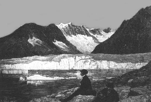 |
Märjelen
in 1889 (old engraving) |
|
|
Panorama
from Eggishorn in 1900 Great panoramic vue, from the top of the Eggishorn, of the glacier of Aletsch, Märjelen and the glacier of Fiesch. On this engraving, note the size of the lake of Märjelen and that the overflow of the lake flows into the valley of the glacier of Fiesch (right). At the end of the XIXth century the glacier of Aletsch was 3 kilometers longer than today, and thicker near Märjelen, that explains this phenomenon of the reversal of the water. Magnifique vue panoramique, depuis le sommet de l'Eggishorn, du glacier d'Aletsch, de Märjelen et du glacier de Fiesch. Sur la gravure notez que le lac de Märjelen occupe la totalité du col et que le trop-plein des eaux du lac se déverse dans la vallée du glacier de Fiesch. A la fin du XIXe siècle le glacier d'Aletsch était plus long de 3 kilomètres et nettement plus épais vers Märjelen ce qui explique ce phénomène d'inversion du partage des eaux. (engraving from the Baedeker Suisse guide, 1901) (240 kb) |
 |
Märjelen
in 1907 (old postcard) |
| To
reach Märjelen from Brig I took the one meter gauge Furka-Oberalp
(FO) railway from Brig (8:39am) to Betten (8:59am), then transfer to the
direct aerial cable way from Betten FO (814m) to Bettmeralp (1935m) in
7'. From Bettmeralp to Märjelen there is a 3 hours walk not really
difficult, the only difficulty is to reach the summit of the crest at
2292m and then you discover the glacier of Aletsch and you must be fascinated
by its beauty and the panorama. Something strange is the fact that you
cannot imagine the real size of the glacier, there is no reference point
to achieve its proportions! Pour aller de Brig à Märjelen j'ai pris le train à voie métrique Furka-Oberalp (FO) de Brig (8:39) à Betten (8:59), correspondance avec le téléphérique direct qui vous envole de Betten (814m) à Bettmeralp (1935m) en 7'. Une marche de 3 heures est nécessaire pour atteindre Märjelen.Pas de grande difficulté sinon qu'il faut monter sur la crête à 2292m avant de découvrir le glacier d'Aletsch et son grandiose panorama. Vous ne pouvez qu'être fasciné par sa beauté mais il est très difficile de réaliser sa vraie dimension car il n'y a aucun point de repère. |
|
 |
The
upper Rhône valley with Brig on the left side and Nätters on
the right. Note on the left border of the photo the entrance of the Simplon
tunnel, on the bottom the iron bridge of the Furka-Oberalp railway. La haute vallée du Rhône avec Brig sur la rive gauche et Nätters sur la droite. Notez à l'extrème gauche de la photo l'entrée du tunnel du Simplon et en bas le pont d'acier de la ligne Furka-Oberalp. |
|
|
 |
|
The aerial cable
way to Bettmeralp at the Betten FO station. The photo shows the cabin
carrying down a garbage truck for the Bettmeralp daily garbage collect.
Bettmeralp is a no-car ressort. |
 |
 |
Bettmeralp
(1935m), behind the chapel and the cloud the Matterhorn (Cervin).
Bettmeralp (1935m), derrière la chappelle le nuage cache le Matterhorn (Cervin). |
|
Click to enlarge
Cliquez pour agrandir |
|
 |
Map
of Märjelen area. The red point is the place of the... accident.
Note that, on the map, the side of a square is 1 kilometer long. So the
glacier is around 2 kilometers width! Carte de la région de Märjelen. Le point rouge indique la position du plantage. Sur la carte un carré a 1 kilomètre de coté, le gacier a donc une largeur d'environ 2 kilomètres! |
 |
Aletschgletscher |
 |
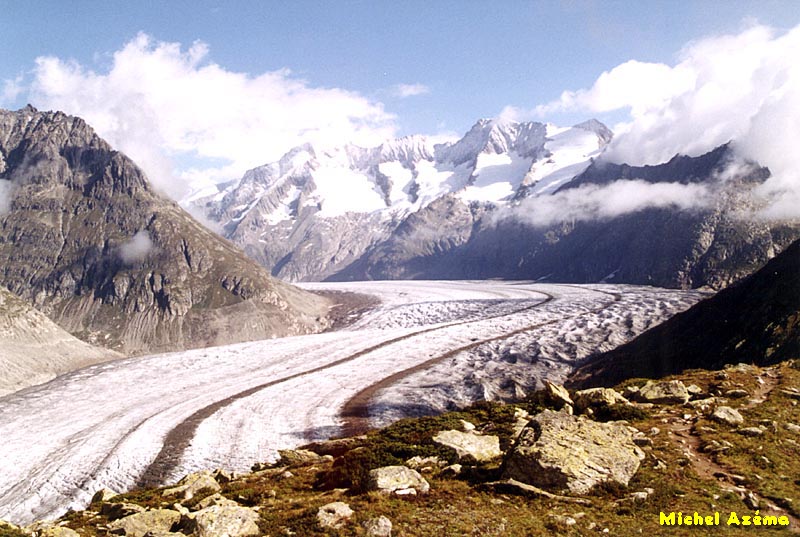
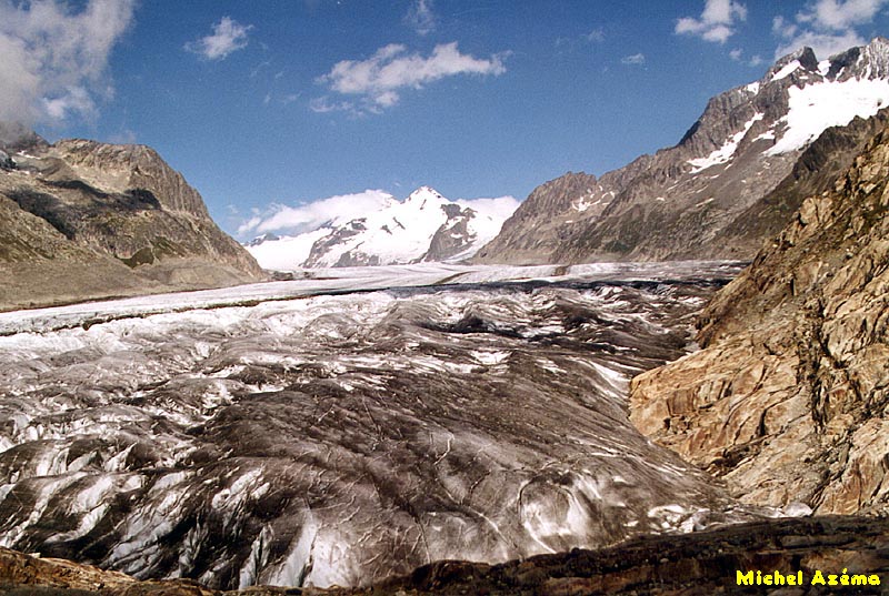
Aletschgletscher The glacier is easilly recognizable with its two dark stripes which are composed of pieces of rock collected and brought by the three main glaciers which compose the glacier of Aletsch, but in fact if you look at the ice you will notice many other small stripes. It means that the three main glaciers are themselves composed of smaller glaciers. Le glacier est facilement reconnaissable à ses deux grandes bandes sombres qui sont des débris de rochers ramassés et emportés par les trois principaux glaciers qui forment le glacier d'Aletsch, mais si vous regardez plus en détail la glace vous noterez qu'il y a de nombreuses autres bandes sombres mais plus petites. Cela signifie que les trois principaux glaciers sont eux-mêmes composés de glaciers plus petits. |
 |
Aletschgletscher From left to right: Frescher Gabelhorn (3875m), Schönbulhorn (3854m), Gross Wannenhorn (3905m), Klein Wannenhorn (3706m) and the cloudy black summit on the right Strahlhorn (3050m). Märjelen is located just below this peack. De la gauche vers la droite: Frescher Gabelhorn (3875m), Schönbulhorn (3854m), Gross Wannenhorn (3905m), Klein Wannenhorn (3706m) et le sommet noir sur la droite Strahlhorn (3050m). Märjelen est situé juste au pied de ce pic. |
 |
Aletschgletscher Looking to the end of the glacier of Aletsch which plunge just in front of the famous forest of Aletsch (on the left of the photo). Vue vers le bas du glacier d'Aletsch qui plonge en face de la célèbre forêt d'Aletsch (à gauche sur la photo). |
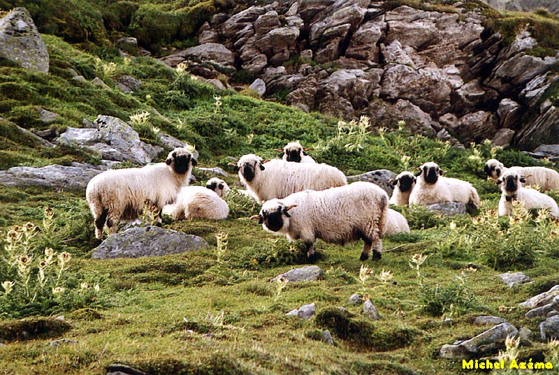 |
Aletschgletscher On the side of the old moraine, the faun is composed of sheep of course but also many chamois and marmots which are continually whistling when they see hikers. Sur le bord de l'ancienne moraine, la faune est essentiellement composée de troupeaux de brebis mais aussi de troupeaux de chamois (de préférence venir tôt avant l''afflux des randonneurs) et des multitudes de marmottes plus difficiles à apercevoir mais qui nous cassent les oreilles avec leurs sifflements continuels chaque fois qu'elles voient un randonneur. |
 |
Aletschgletscher Upstream view of the glacier. The snowy peak, on the left, is the Trugberg (3932m). Just below it is the Konkordiaplatz where the three primary glaciers merge. Vue en amont du glacier. Au bout du glacier le sommet enneigé est le Trugberg (3932m). Juste a ses pieds se trouve la Konkordiaplatz où les trois glaciers originels se rejoignent. |
 |
Aletschgletscher Above the glacier of Aletsch and from left to right: the Aletschhorn (4195m) with the Mittelaletschgletscher, Olmenhorn (3315m) and Trugberg (3932m). Au dessus du glacier d'Aletsch et de gauche à droite: Aletschhorn (4195m) avec le glacier Mittelaletsch, Olmenhorn (3315m) et Trugberg (3932m). |
 |
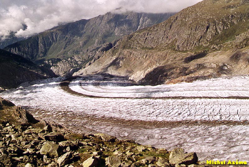
Märjelen We are now arrived at Märjelen, in the natural elbow of the glacier. 100 meters below is the lake of Märjelen, the goal of the trip. Nous sommes maintenant arrivés à Märjelen, situé au coude du glacier, 100 mètres en contre bas se trouve le lac de Märjelen, le but de la randonnée. |
 |
Märjelen On this photo we can see that the lake of Märjelen seems to be empty. You can see the front of the glacier with the white ice newly cut from the mass. The height of this white ice is around 10 to 15 meters. When part of this ice comes out from the glacier, with the action of the water of the lake, it becomes a real iceberg. Sur cette photo on s'aperçoit que le lake de Märjelen est vide. On voit que le glacier s'est brisé en découvrant un front de glace blanche qui a une hauteur de 10 à 15 mètres. Lorsqu'un pan de glace se détache il forme un véritable iceberg. |
 |
Märjelen Way down to the lake of Märjelen. As the lake is quite empty, I decided to go down into it, as I already did in October 1990. As you can see the lake is not completely empty, there are some greenish water with some small icebergs. On the foregroung, some bigger icebergs been beached on the stones, surprised by the fall of the lake level. Note the big hole digged into the mass of the glacier. Descente au fond du lac de Märjelen. Comme je l'avais déjà fait en Octobre 1990, je suis descendu au fond du lac, pas tout à fait vide car il y avait de l'eau verdâtre sur laquelle flottaient des petits icebergs. Au premier plan des icebergs beaucoup plus impressionnant sont posés sur les rochers, surpris par une descente du niveau du lac. Notez l'énorme trou béant dans la masse du glacier. |
 |
Märjelen Close-up to the lake and the big hole into the glacier. This is also the last photo taken during this day! 5 seconds later... the accident! Gros plan sur le lac et le trou béant sous le glacier. C'est aussi la dernière photo prise durant cette journée. 5 secondes après... the accident! |
|
|
Märjelen 12:15am I wanted to go closer the lake and the white ice cliffs. On a humid inclined stone my right foot suddenly slept (as on a soap or ice) to the left, I put my right hand to absorb the fall. When I was standing again, I felt a big pain in my wrist which became swollen. I decided to get out the bottom of the lake and try to reach a refuge in Märjelenalp after 45'. There I decided to eat something and try to reach the aerial cable way on the other side of the Eggishorn which is a very long walk but the only reasonable way. Fortunately I was informed of the existence of a one kilometer long lighted tunnel under part of the Eggishorn! This tunnel is not indicated on the map. After a 2 hours walk I finnaly reached Kühbodenstagel (2221m) where there is the aerial cable tramway down to Fiesch (1050m) on the Furka-Oberalp line. Then I took thr first FO train to Brig where I arrived at 4:00pm. 12:15 Je voulais me rapprocher des falaises de glace blanche. Sur une pierre plate inclinée et mouillée mon pied droit dérappa brusquement sur la gauche, je mis ma main droite en opposition pour essayer d'amortir la chute. Une fois debout j'ai senti une vive douleur au poignet droit tandis que celui-ci se mit immédiatement à enfler. Je décidais de sortir du fond du lac et de rejoindre un refuge situé sur l'alpe de Märjelen après 45' de marche difficile. Après avoir mangé un rösti je décidais d'essayer de rejoindre le téléphérique derrière l'Eggishorn ce qui était le chemin le plus raisonnable. En 1990 j'étais redescendu à pied sur le glacier de Fiesch de l'autre cotè de Märjelen mais c'était vraiment une descente longue et dangereuse. Heureusement j'appris l'existence inespérée d'un tunnel (éclairé) long de 1 kilomètre sous une partie de l'Eggishorn ce qui doit raccoucir le chemin d'une bonne heure. Après deux heures de marche je rejoignais enfin Kühbodenstagel (2221m) et le téléphérique Eggishorn-Fiesch. Fiesch est situé sur la ligne du Furka-Oberalp, je pris le premier FO vers Brig où j'arrivais à 16:00. |
 |
Brig Thank you for the
Hotel Europe at Brig and
their employees for their kindness. |
|
Glacier of Aletsch and Märjelen
in October 1990
Glacier d'Aletsch et Märjelen en Octobre 1990 |
|
|
|
Aletschgletscher In October 1990, the cloud ceiling was very low about the glacier, it was a very strange atmosphere. En Octobre 1990, le plafond était très bas au dessus du glacier ce qui donnait une atmosphère à la fois étrange et inquiétante. |
 |
Aletschgletscher Under the clouds, the first snow after the summer. Sous les nuages, les premières neiges après l'été. |
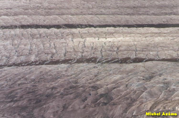 |
Aletschgletscher Close-up of the two main stripes. There is quite 400 meters between the two stripes. Gros plan sur les deux bandes principales qui sont séparées d'environ 400 mètres. |
 |
Aletschgletscher Two chamois on the lateral moraine. Deux chamois sur la moraine. |
 |
Märjelen In October 1990 the lake of Märjelen was completely empty. Note the big hole where the lake was siphonned and the big icebergs. En Octobre 1990 le lac de Märjelen était complètement vide. Notez l'énorme trou sous le glacier par lequel les eaux du lac ont été siphonnées. |
 |
Märjelen The imposing mass of the glacier just above the hole. La masse imposante et luisante du glacier juste au dessus du trou. |
 |
Märjelen A big iceberg stranded on the rocks. This iceberg is 4 meters height. Un gras iceberg haut de 4 mètres échoué sur les rochers. |
|
Glacier of Aletsch in October 1987
Glacier d'Aletsch en Octobre 1987 |
|
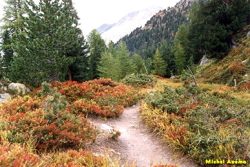 |
Aletschwald The famous and wonderful forest of Aletsch located at the end of the glacier. Here a field of blueberries. La célèbre et magnifique forêt d'Aletsch située à la fin du glacier. Ici sur la photo un champ de myrtilles. |
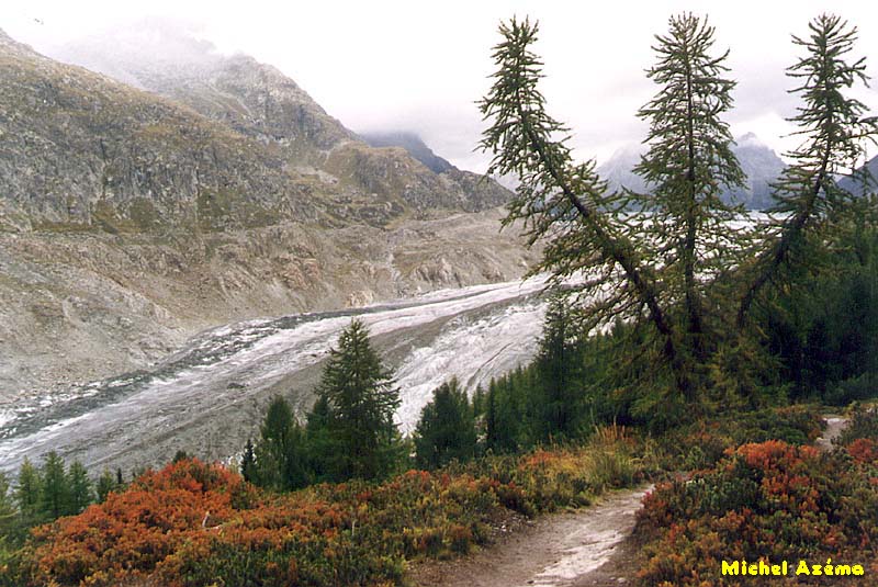 |
Aletschwald
and
Aletschgletscher The end of the glacier of Aletsch under the forest of Aletsch. La fin du glacier d'Aletsch en contrebas de la forêt d'Aletsch. |
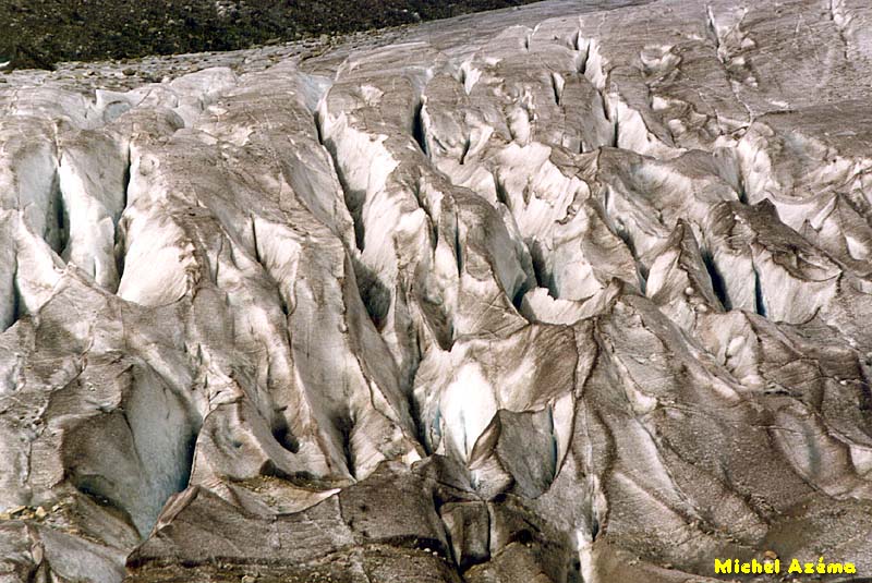 |
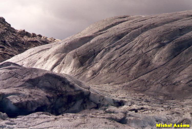
Aletschgletscher Close-up of the crevasses. Gros plan sur les crevasses du glacier. |
| |
Copyright ©
1999 by Michel Azéma, Paris (France) |
Warning: All images are copyrighted and are intended for personal use only. They may not be reproduced in any form without the explicit permission of the copyright owner. |
|